Mistaken Point

Newfoundland_map
There’s a problem in writing about Newfoundland: It’s an unassuming place, with few of the Michelin green guide must-see attractions. Some of the best sights are poorly marked or hard to reach.

There are little-known attractions here that rival the most famous sites in the world, and some are unique to the area. I keep experiencing what I think is the highlight of the trip, only to have another even more engaging experience. A recent one was at Mistaken Point.

Background

But first, a little background: In 1868, the Scottish geologist Alexander Murray discovered unusual an fossil now called Aspidella terranovica. Four years later, Elkanah Billings found these at the corner of Duckworth and Holloway Streets, where they can still be seen today, unmarked and unprotected in the back of a parking lot. The fossils are in a Precambrian outcrop of black shale.

This was deemed impossible. Scientists believed that the Precambrian period was the time before the Cambrian explosion of multicellular life on earth. There should be only microscopic bacteria, fungi and the like. Others claimed that these were inorganic concretions, gas escape bubbles, or fakes planted by God to mislead those with little faith.

The doubts continued until mid 20th century. Then, Reg Sprigg discovered an assemblage of fossils in the Ediacara Hills of South Australia, which confirmed the existence of multi-celled organisms on Earth between 635 million and 542 million years ago. They’re now found in many parts of the world, especially in now-dispersed regions (England, FLorida, NW Africa, Newfoundland) that were once part of the Avalonia terrane. Some of the best examples of these fossils are in Newfoundland, including at Port Union and St. John’s.

These discoveries answered a question that Darwin raised in On the Origin of Species: Why didn’t the fossil record show more experiments with multicellular life prior to the Cambrian explosion? It now appears that the Avalon explosion was one such, with a variety of diverse and fascinating plants and animals.

In 1967, graduate student S. B. Misra, discovered and documented similar fossils found in great numbers on exposed rock surfaces at Mistaken Point along the southeasternmost coast of the Avalon Peninsula. Mistaken Point is so named because of the difficulty of navigating in the treacherous waters surrounding the point, which led some navigators to turn north too soon, when attempting to go around the peninsula.

Mistaken Point tour

I’m not a fan of guided tours, but I’m glad that the ecological reserve at Mistaken Point now requires that. Fossils that have lasted 565 million years can be destroyed in a weekend by humans.

We signed up for a tour that lasted most of the afternoon. After seeing the fossils, we went on to the nearby eastern point of Cape Race, which has one of the most powerful and important lighthouses in the world. It’s also the site of the Marconi wireless station that received the first distress message from the Titanic.

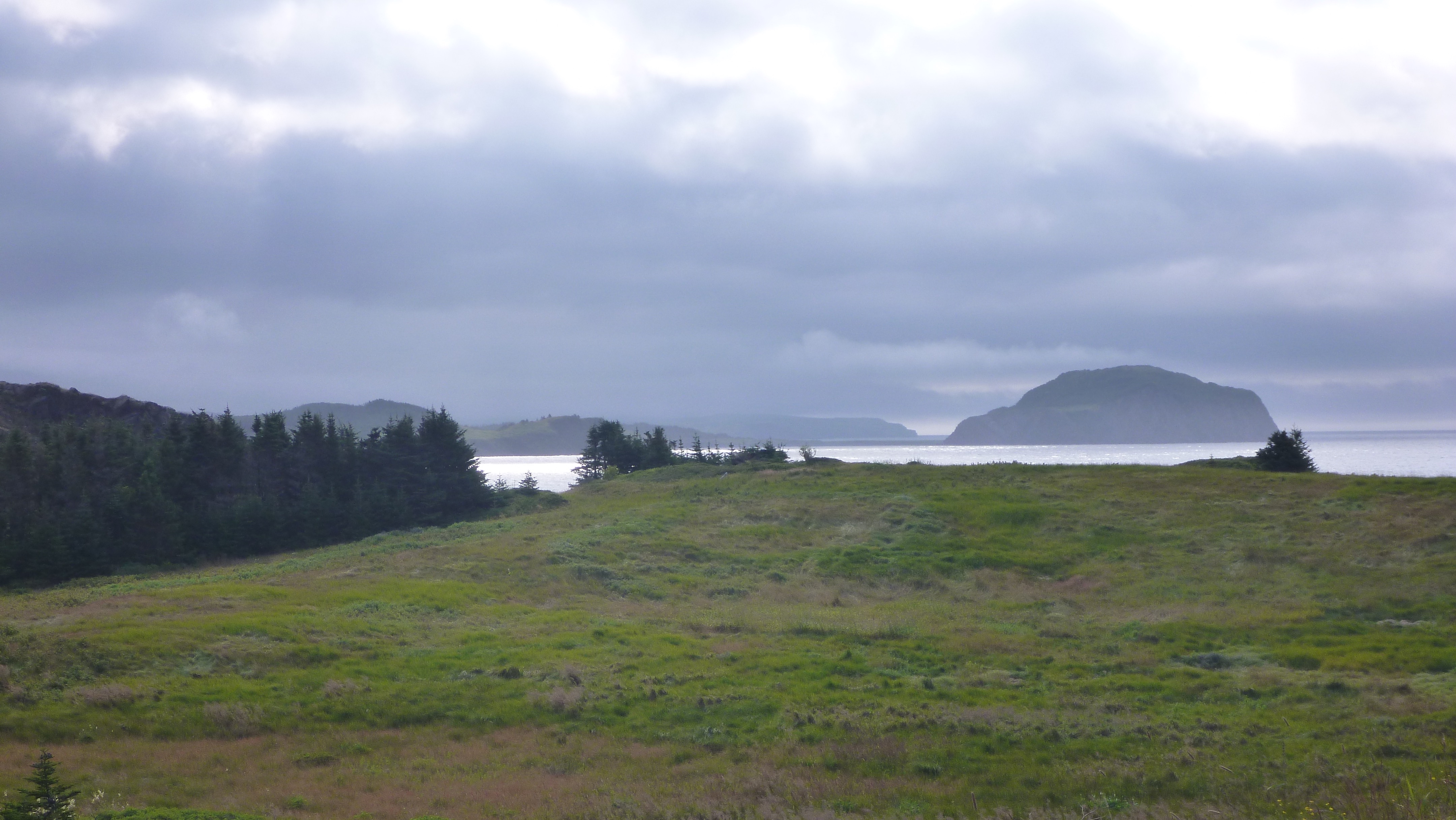
You can see a bit of our tour in the slides below. We were given a good introduction to the natural history of the area on the 45-minute walk out across hyper-oceanic barrens. We had to wear booties to avoid damaging the fossils.

We were able to explore shelves which had lain at the bottom of the ocean over 565 million years ago, populated by creatures that have never been seen alive.

This whole experience was one of the highlights of our trip.

This slideshow requires JavaScript.

“First Life with David Attenborough” has more about these early creatures, including the fractal nature of their body organization:

A union-built town

Band saw in the restored factory

Band saw in the restored factory

Port Union is a gem that I knew nothing about. It seems little understood by Wikipedia or Google searches, or even many locals. Yet it’s a fascinating site and story, and an important one for anyone interested in workers’ rights or community building. The new museum and other facilities are well worth a visit, even if you have no interest in dramatic seascapes, quaint Newfoundland port towns, Ediacaran fossils, handmade crafts, or beautiful nature walks.

The town claims to be the only union-built town in North America. Some others might quibble. For example, Nalcrest, Florida was conceived, designed and financed by the letter carriers union as an experiment in retirement housing. Cities such as Chicago and St.Louis are often described as “union-built towns.” But it’s hard to find examples anywhere of a town so fully conceived and established of, by, and for a union.

The founding of Port Union

William Ford Coaker, 1871-1938

William Ford Coaker, 1871-1938

William Coaker founded the town as the base for the Fishermen’s Protective Union in 1917. During 1908-09, he had travelled around Notre Dame Bay, seeking support for a union in each of the tiny communities. By the fall of 1909, the FPU had 50 local councils. By 1914, over half the fishermen in Newfoundland had become members.

In rapid succession, the FPU and the town established a trading company to break the merchants’ stranglehold on salt fish trade. They soon built workers’ housing, a retail store, a salt-fish plant, a seal plant, a fleet of supply and trading vessels, a spur railway line, a hotel, a power-generating plant, a movie theatre, a school, and a factory to build these facilities and other things the community needed.

Clamps for door making

Clamps for door making

There was much more, including even a soft drink (or ìtemperance beverage) factory. One of the most important enterprises was the influential Fishermen’s Advocate newspaper.

Reaction and decline

The anthem of the Fishermens Protective Union was sung at FPU meetings to show support for Coaker and his movement to unite the fishermen. It starts as follows:

We are coming, Mr. Coaker, from the East, West, North and South;
You have called us and we’re coming, for to put our foes to rout.
By merchants and by governments, too long we’ve been misruled;
We’re determined now in future, and no longer we’ll be fooled.
We’ll be brothers all and free men, we’ll be brothers all and free men,
We’ll be brothers all and free men, and we’ll rightify each wrong;

Calculator scale

Computing scale used in the retail store

There was widespread support among the fishing communities for Coaker and the FPU. Coaker himself had a successful career in the Newfoundland House of Assembly and as minister of marine and fisheries through 1924.

But they union was attacked by moneyed interests and the Catholic church. Eventually, it lost power and its political role ended in 1934. The cod fishing moratorium furthered the community’s decline.

By the late 1990s, the town was no longer a commercial center and was in a state of neglect. In 1999, the original part of the town and the hydroelectric plant were designated a National Historic Site of Canada.


Questions and connections

I came away from Port Union with many questions. I’ve read that the FPU drew from and influenced the farmer’s co-operatives in the western provinces. I wondered though whether it was connected with enterprises such as La Bellevilloise in Paris, which was founded earlier, after the Commune. It was the first Parisian cooperative project to allow ordinary people access to political education and culture. It, too was a place of resistance with a “from producer to consumer” motto. There were similar projects in Ireland and England, which might have provided a more direct link for Coaker.

The FIsherman's Advocate

The Fisherman’s Advocate

Coaker lived nearly contemporaneously with Jane Addams. Although her settlement house work was not directly union organizing, it shared in the effort to provide self-contained services and to promote workers’ rights.

The earlier Toynbee Hall in London’s East End sought to create a place for future leaders to live and work as volunteers. It was created out of similar motives, and the realisation that enduring social change would not be achieved through individualised and fragmentary approaches. I’d like to learn more about how, if at all, these enterprises learned from one another.

What if

I’d also like to learn more about Coaker himself. Michael Crummey’s novel Galore includes Coaker as a major character. In an interview, Crummey describes the actual Coaker as an enigma and the FPU experience as a pivotal moment:

It is the great “what if” moment in our history. The entire story of 20th century Newfoundland would have been completely different if Coaker had succeeded. We might still be an independent country.

Even truncated as it was, what Coaker accomplished was extraordinary. Delegations from a number of Scandinavian countries came to study what he was up to and implemented many of the reforms in their own fishery that he was fighting for.

Visitor density

Devil's Cove and beyond

Devil’s Cove and beyond

There are similarities between Cape Cod (CC) and Newfoundland & Labrador (NL). Both are beautiful, have long histories connected with the sea, are more residential than industrial. Even details of the fishing are similar–cod, lobster, and shellfish. Many people remark that NL is like CC of fifty years ago.

One obvious difference is the impact of tourism. That’s very evident on CC, especially in July through August, until school resumes. Tourism is important in modern NL, too, but it’s less intense and more spread out.

I did some calculations, which showCape Cod’s well-deserved appeal draw for visitors. They also show why Newfoundland & Labrador appeals to those who seek a place away from population centers, including centers created by lots of visitors.

My data are not ideal. They’re from different sources and years as well as being incomplete on points such as length of stay. One could argue about whether Labrador ought to be included in this kind of comparison.

Nevertheless, the larger story seems clear. It explains why life is much calmer in NL than on CC, especially in August

Cape Cod

visitors/year – 5.23 M
area – 339 mi²
visitors/year/area – 15,428

Newfoundland & Labrador

visitors/year – .50 M
area – 156,453 mi²
visitors/year/area – 3

NL area / CC area – 462

NL visitor density / CC visitor density .0002

The reciprocal of the last figure says that there are nearly 5000 CC visitors in a given area for a single NL visitor.

It’s only fair to mention that I haven’t been to Signal Hill in St. John’s yet. I expect that it may present a different picture from the tiny outport communities.


Moveable feasting

You can’t count on a 4 mph pace on the trails of Newfoundland, even if you can walk faster than that on flat ground. Even 3 mph or 2 mph is hard to manage. In fact, you stop thinking about the pace.

The problem is not the terrain per se. I’m convinced that it involves more walking uphill than down. There are also uneven rocks, loose gravel, bogs, overgrown vegetation, fallen trees and other obstacles. And the occasional bugs and thorns. But you can get used to all of that.

A much bigger problem is the amazing views, even on the most ordinary trails. I’ve learned not to be captive of the camera, but it’s hard not to stop to look at waves crashing against a sea dungeon, to study 560 million year old Ediacaran fossils at Port Union, or to be captivated by abnormally cute puffins on the island off of Elliston Point. Those sights and more are within a 45 min. drive from our house.

But there is a bigger problem still: The trails are edible. It’s hard to keep up the pace when lunch beckons at every turn.

On a short walk yesterday, we saw ripe bakeapples (cloudberries), low-bush blueberries, and raspberries. There were chuckly-pears or chuckle-berries (amelanchier) and dogberries on the small trees, ready to eat. Nearby were partridge berries and cranberries. We’ve also sampled strawberries, juniper berries, bearberries, bunchberries, and many I can’t identify.

These delicacies were right next to the trail, far more than enough for the sparse walkers. When I’d look off the trail, I sometimes saw masses of berries enough for pies and muffins and pancakes, for jams, for adding to cereal, and for munching to keep my energy up.

There are many other edible berries. In addition to the berries on ground cover-type plants, there are fruits, some called berries, on bushes and trees. There are also numerous edible plants and mushrooms.

Click on any image below to see larger, slideshow format.

Port Rexton

Our longest stay in Newfoundland is in Port Rexton, on the Bonavista Peninsula. Close by are the historic town of Trinity with an excellent local theater, Port Union, the only union-built town in North America, shale formations with Ediacaran fossils, bays with dolphins and whales, great walks along seaside cliffs and through forests, freshwater ponds, sea birds, and more.

The pictures below are just to give an impression of the community itself, most of them taken on a walk to the nearby coffee shop.

Desmond X. Holdridge

Whaler and fishing vessels near the Coast of Labrador, William Bradford

Whaler and fishing vessels near the Coast of Labrador, William Bradford

I’ve been learning about Desmond X. Holdridge, starting with a quote about boats from his book about sailing around Newfoundland and Labrador:

For boats, even the uglier ones, are among the loveliest creations of man’s hands, and though owning them brings a train of debts, hangnails, bruises, bad frights and all kinds of worries not experienced by those who content themselves with more practical vices, the relation between a man and his boat is as personal and intimate as the relation between husband and wife. –Desmond Holdridge, Northern lights: A voyage into danger, 1939

Holdridge was an explorer and author who lived a short, but interesting life (1907-1946). It was filled with dangerous expeditions and the extreme versions of the nautical disasters that I thought only I could create. He died in an automobile accident near Baltimore (Democratic Advocate, April 19, 1946).

When Holdridge was 14 he fitted a rowboat with a sail. Soon after, he was caught in a squall and crashed the boat. At age 18 he and two others sailed a 32-foot schooner for six months around Nova Scotia, Newfoundland, and Labrador. A five-day gale battered his boat to pieces on that trip but they were rescued by another schooner.

Holdridge was again feared lost at age 21. He visited Labrador in to find evidence of Martin Frobisher’s colony from his search for the Northwest Passage in 1576, possibly on Resolution Island.

Not long after that, Holdridge went on an expedition to the jungles of southern Venezuela. His camp was attacked one night, but the attackers fled when he blew the campfire into flames.

The end of the river (film)

The end of the river (film)

Holdridge wrote about that expedition in several books, including the novel, The End of the River, about a South American Indian boy who leaves the jungle for the city where he is accused of murder. That novel was the basis for a film produced by Powell & Pressburger (1947), which was made in Brazil.

He also wrote technical articles, such as “Exploration between the Rio Branco and the Serra Parima” for Geographical Review (1933). He writes there:

The section of northern Brazil enclosed by the Negro, Branco, and Uraricoera rivers and the Serra Parima has long been indicated on maps of Brazil as terra incognita and it was in the hope of finding there aboriginal cultures unchanged by contact with white men that the writer’s expedition was undertaken. During the seven months from May to November, 1932, explorations were conducted on three of the five large tributaries of the Amazon system that have their sources in the Serra Parima–the Catrimany, Demini, and Aracat.

Throughout the several journeys low mountains at strategic points were ascended and bearings taken from them on near–by and distant peaks and sketches made. The resulting network of bearings constitutes a rough triangulation of the whole region and with the photographs and sketches has made possible the construction of a map giving an approximate representation of the topography. A part of the Brazil-Venezuela boundary, following the crest of the Serra Parima, lies within this area, and as a consequence its delineation will be quite different from any shown heretofore.

Holdridge lived for the adventure and writing about it. Speaking of a Labrador storm, he says:

that storm was another symbol, a symbol for the absolute of insensate fury… And here, I think, is the reason for much seafaring, especially for the kind that is conducted in small boats. From the experience of such dreadful chaos there is a catharsis obtainable from no possible work of art…

in the flying Dolphin, her very presence on the surface not predictable even for seconds into the future…

the coexistence of abysmal terror and god-like elation is responsible for much seafaring, especially the small-boat kind… the survivor feels that, if he can design and build the perfect vessel, there will be no terror and only that tremendous thrill. Hence the buckets of drawing ink and the miles of timber that go every year into the building of small seagoing yachts, accompanied always by more money than their owners can afford, and it must make an economic determinist feel like a fool. –Desmond Holdridge, Northern lights: A voyage into danger, 1939


Skerwink Trail

Sea stacks

Sea stacks

We just walked the beautiful Skerwink Trail, which is reachable by a short path from our house rental. The trail loops around Skerwink Head, a rocky peninsula between Port Rexton and Trinity East, Newfoundland.

The peninsula is mainly sedimentary rock, especially sandstone. It’s been shaped into fantastic cliffs, sea stacks, arches, and beaches by the Atlantic storms and freeze/thaw cycles.

Along the walk we saw whales and seabirds, wildflowers, mushrooms, edible wild berries, and a variety of habitats, including determined plants on steep cliffs, mixed forest, craggy meadows, tuckamore, bog, freshwater pond, birch tree clusters, and gravel beach.

The early day was foggy and drizzly, but by late afternoon the sun was shining. A gentle breeze turned into a stronger wind than I liked in the exposed areas.

The trail is considered moderate–difficult. Numerous steps, boardwalks, and rails are what makes it moderate. There is also good signage, including several “Caution” or “Danger: Unstable cliffs.” As an accomplished acrophobe, the recommendation for caution was unnecessary for me. I could easily see the danger, and instead wished for a “Turn back now!” sign.

We celebrated the end of the walk with a dinner of fresh mussels purchased from a roadside truck at Trinity Bay, where they’re farmed. Steamed in white wine and accompanied by some garlic mayonnaise, they were delicious. It didn’t hurt that the price was a little over $1 (US)/pound.

You can see some of the sights in the slides below and on the Skerwink Trail site.

This slideshow requires JavaScript.


Clints and grikes

Clints and grike

Clints and grike

We’ve walked on more interesting trails in Newfoundland than I can count, and those are a tiny fraction of the possibilities. Many are in National or Provincial Parks; some are on private land or Crown Land. Since 95% of Newfoundland and Labrador is provincial Crown Land, there’s a lot to explore.

Some of the trails have been developed by small towns, including outport communities. For example, Flower’s Cove on the Great Northern Peninsula has the White Rocks Walking Trail. This wanders across a limestone barrens, where I learned firsthand about clints and grikes.

Limestone barrens

Limestone barrens

Limestone barrens are odd, unforested areas with what appear as large, limestone paving stones, mortared with mosses, small conifers, wildflowers, and other flora. These are unique ecosystems with extremes hot and cold, plus cycles of drought and flooding and frost. They represent less than 1% of the total area of the island, but host 10% of the rare plants.

The limestone pavement of the barrens is a type of karst landform. These formations have blocks, called clints, separated by deep vertical fissures known as grikes. Karst is derived from the Slovenian word kras, meaning a bleak, waterless place.

Solied pants

Solied pants

From experience, I strongly advise you to be careful, stepping only on the clints. This advice is not always easy to follow, since plants grow up through the grikes and often spill over onto the clints. Thus it’s possible to step on what seems to be a thin layer of green on the clint and find your foot going deep into a grike.

This happened to me near the end of a walk. My left foot sank down nearly up to the knee. I the fell forward hitting both knees on the clint. I was just lucky that I hadn’t caught the foot more, or I might have had a twisted ankle or even a broken foot, possibly one wedged into the grike. Since I was walking alone at the time, I might have come to understand truly what Slovenians mean by kras.

Instead, I suffered no worse than embarrassment and soiled pants.

Completing the circle

Matthew replica

Matthew replica

We’re staying near Bonavista, possibly where John Cabot landed his ship, the Matthew, in “New Founde Lande” on June 24, 1497. There’s a plaque in the cottage commemorating “the 500th anniversary” with celebrations held in 1997. However, the human presence here is much longer than that celebration suggests.

Newfoundland is famous for its dramatic, detailed, and precise record of life on earth. This includes two of the most important GSSPs, or Global Boundary Stratotype Section and Points, one of which we saw at Green Point. Its record of human life is becoming more fleshed out as well.

Recreated long house

Recreated long house

This shows that the cultures of Newfoundland are intertwined over many millennia, just as the mixed forest, slips into tuckamore, then tundra, building upon and shaping each other. That’s true everywhere of course, but the connections seem more evident here, and are notable for a relatively small, non-urbanized population.

For example, Newfoundland was one of England’s oldest colonies, reflecting Cabot’s voyage in 1497. However, in the 17th-century it was more French than English. Those French were largely Normans, Bretons, and in the western area we first visited, Basque. The English kept the French place names, but chose to pronounce them in the English, or sometimes the uniquely Newfoundland way.

Carlb-ansemeadows-vinland-02

English and French records show that during this time Mi’kmaq families were active along the Western coast. They incorporated the island of Newfoundland along with Cape Breton into their domain of islands. I was surprised to learn that in discussions of cultural eras, they’re often now grouped with the European period, due to the timing, their close interaction with the Europeans, and the fact that many were Roman Catholic.

The long history of Newfoundland with its connected cultures can be seen at L’Anse aux Meadows, a site at the far north end of the Northern Peninsula. It was discovered only in 1960. The settlement probably supported Leif Erikson’s attempt to establish the colony of Vinland, 500 years before Cabot’s voyage. This makes it the best evidence for first contact between peoples of Europe and America and the most famous site of a Viking settlement in North America outside of Greenland.

World Heritage Convention symbol at L'Anse Aux Meadows

World Heritage Convention symbol at L’Anse Aux Meadows

L’Anse aux Meadows might have been presented as the beginning before the beginning–the voyage that was 500 years before what we had earlier celebrated as the first one. Instead, the site today rightly talks about those who came to greet the Vikings, who they were and where they came from.

Tracing back, it shows how early modern humans left Africa 100,000 or more years ago. Some dispersed across Asia then moved into North America and eventually Newfoundland from the west. Others went north into Europe, Iceland, Greenland, and eventually from the east.

L’Anse aux Meadows thus represents many things. But one of the most significant is the reconnection of these streams of humanity. The metaphor of “completing the circle” symbolizes the completion of human migration around the world. The Vikings and the Dorset or Late Palaeo-Eskimos were the front people in this re-encounter.

L’Anse Aux Meadows is a UNESCO World Heritage site. Its story aptly reflects the World Heritage Convention symbol, with its emphasis on global connection.

Blow Me Down

Towards Lark Harbour

Towards Lark Harbour

Trail through forest

Trail through forest

Trail through open area

Trail through open area

When, in the middle of August, you need to light up the wood stove to warm your feet, there’s snow at 2000 feet, and an iceberg floats by your cabin window, you know that you’re in an unusual place.

A close encounter with a caribou on a hiking trail, meeting a traditional carver of stone and bone, and eating cod caught a few hours earlier by the restaurant owner’s two young sons add to the pleasant surprises. But the most remarkable thing about Newfoundland are the stories.

Serpentinite

Serpentinite

Every local we meet seems to have a trove of stories, freely mixing what some Viking did a thousand years ago with what they ate for breakfast. And every place, remarkable though it may be on its own terms, comes packaged with intertwined history, myths, and legends,

Beyond the island in front of our lodging in York Harbour was the Blow Me Down Mountain (650 m). Its name comes from the story in which Captain Messervey in 1771 anchored his boat below the range and said “I hope they don’t blow me down!” To this day it’s famous for its powerful winds that blow in every direction at once. It’s also known as an amphitheater that amplifies the sound of thunder. I heard stories of walkers fleeing in terror when Thor seemed to go on a rampage.

Blow Me Down mountain

Blow Me Down mountain

Stairway in a cave

Stairway in a cave

There have been at least 17 communities that share the odd name of Blow Me Down, not to mention mountains, mountain ranges, parks, and other geographical objects.

We took a walk through Blow Me Down Provincial Park nearby, which generated some personal stories to add to the corpus. The trail was beautiful, but a bit of a workout, because of the mud and running water from a recent storm. My activity tracker thought it was more than 100 floors up.